In recent years, the term “gorilla hail” has emerged in meteorological circles to describe exceptionally large and destructive hailstones. Coined by storm chaser and meteorologist Reed Timmer, the phrase captures the immense size and potential damage of these ice chunks. Read on to learn more!
What is gorilla hail and how does it form?

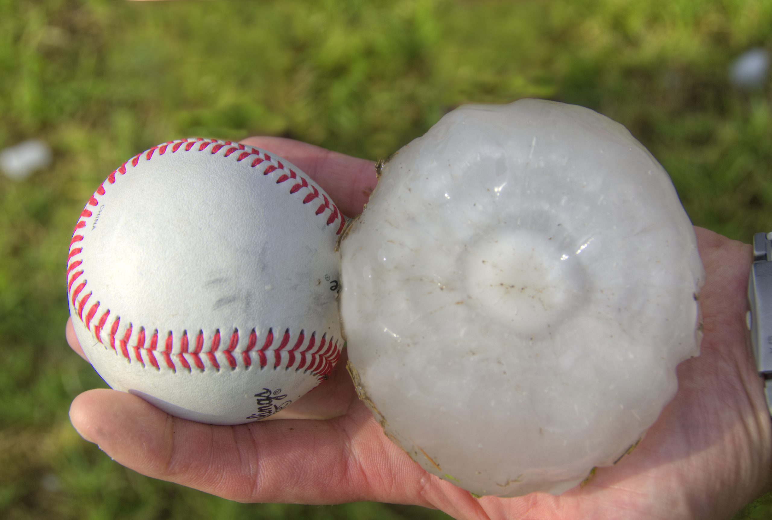
Gorilla hail refers to unusually large hailstones, typically measuring two inches or more in diameter. These massive ice balls form within severe thunderstorms when strong updrafts carry water droplets high into the atmosphere, where they freeze and accumulate additional layers of ice before falling to the ground.
The term “gorilla hail” is not a scientific classification but rather a colloquialism popularized by Timmer to convey the extraordinary size and destructive power of such hailstones.
The damage inflicted by gorilla hail can be extensive. Vehicles often suffer shattered windshields and dented bodies, while homes may experience broken windows, damaged roofs and punctured siding.
Beyond property damage, these large hailstones pose a significant risk to personal safety, capable of causing serious injuries or even fatalities to those caught outdoors during a storm.
Where gorilla hail strikes most in the U.S.

Gorilla hail is most prevalent in the central part of the country, where weather patterns create ideal conditions for powerful thunderstorms. The region is known as “Hail Alley” and stretches across parts of eastern Colorado, western Nebraska and eastern Wyoming.
Warm, moist air from the Gulf of Mexico frequently collides with cooler, drier air from the Rockies, creating vertical wind shear and strong updrafts that allow hailstones to grow to extreme sizes.
Texas, in particular, experiences a high volume of large-hail events, with its vast geography and variable elevation contributing to volatile storm development.
According to data from the National Weather Service, central and northern Texas average more hail days per year than most other parts of the U.S. Meanwhile, states like Kansas and Nebraska often report hailstones among the largest in the country, thanks in part to open terrain that allows storms to intensify.
Meteorologists note that while Hail Alley remains the traditional hotspot, extreme hail has become more common in outlying areas, including the Southeast and Midwest, suggesting a broader geographic range as climate patterns shift.
Recent gorilla hail events that made headlines

Several notable gorilla hail events have occurred across the U.S. in recent years, underscoring the growing threat posed by these severe weather phenomena.
In April 2021, central Texas experienced a supercell thunderstorm that produced hailstones up to the size of grapefruits. The storm caused significant damage to vehicles, with numerous reports of dents and shattered windshields.
More recently, in May 2024, central Texas was again battered by gorilla hail, with reports of hailstones measuring between four and six inches in diameter. These massive ice chunks caused extensive property damage and raised concerns about public safety.
In March 2024, Kansas and Missouri faced a severe weather event that brought gorilla hail to the region. The storm resulted in significant disruptions, including halted traffic and widespread property damage.
These incidents highlight the destructive potential of gorilla hail and the importance of preparedness and timely warnings to mitigate risks associated with such extreme weather events.